

























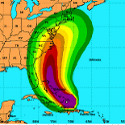
 Two global forecast models, the European and the NOAA’s “GFS”, have shifted the track slightly westward increasing the risk of severe impacts to the coast of the mid-Atlantic and New England. The National Hurricane Center has adjusted its official track slightly westward bringing Irene’s center near the North Carolina Outer Banks then north-northeastward (paralleling the Delmarva coast) over the east end of Long Island, before crashing it into Rhode Island.
Possible impacts in these areas including flooding rain, a dangerous storm surge, severe coastal flooding and damaging winds. It is important to remember small changes in the storm’s track could result in lesser (or more severe) impacts, and errors are still large at this range. NOAA